City staff are recommending two sections of Arbutus greenway be the first to be developed along the nine-kilometre route. One section — “The Ridge” — is located south of West 16th, while the other — “The Lookout” — is at the southern end.
The corridor has been divided into eight sections for design and implementation purposes. Known as "character zones," they're inspired by features of the areas.
“The Ridge” (zone three) sits between West 16th and West King Edward Avenue, while “The Lookout” (zone eight) stretches from Southwest Marine Drive to Milton Street. The two sections were prioritized for development after all eight sections were evaluated and scored based on criteria including visibility, project readiness, connectivity, equity, safety, relative cost and population density. "The Lookout" scored the highest.
Buildout for the entire greenway is expected to take place over many years and at least four capital plans. Along with cycling and pedestrian paths, and various design elements, space is also being dedicated on the route for a future street car. A timeline and funding for the streetcar has not been established yet.
The first phase of the project, subject to council approval and funding availability, is envisioned for the 2019 to 2022 capital plan cycle. If only partial funding is available, one or both of the zones could be partially developed, with the completion deferred to a future capital plan.
Staff’s recommendations are outlined in a design vision and implementation strategy report going to council July 11. Read the report HERE.
Aside from initiating work on the two zones, staff recommend the first phase include:
- a southern extension to the Hudson street-end park and the Fraser River
- a northern extension from the greenway to False Creek and the Seawall (Seaside Greenway)
- short-term spot improvements to improve safety and comfort for people walking, wheeling and cycling
- coordination of zone one greenway planning with the Vancouver Park Board’s park planning in zone one, (West Sixth Avenue and Fir Street Park, Delamont Park)
If council approves the recommendations, staff will start detailed design and technical work for phase one. It will include further public consultation.
Funding is already secured for staffing and design costs during this phase, while capital costs are expected to be funded from a combination of Community Amenity Contributions (CACs) from new developments in the area and external sources, according to the report.
Staff will seek contributions from all three senior levels of government, with an eye to securing at least 50 per cent of capital costs from these sources.
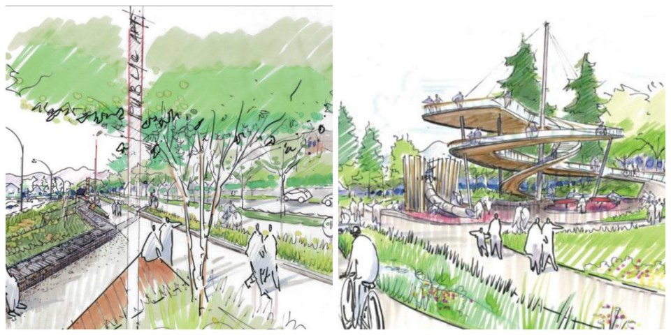
“The Ridge,” a.k.a. zone three, is the most expansive section of the greenway. It has views of the mountains and English Bay and the design envisions “nooks” where users can sit and relax. Plans include lighting, benches and other amenities, a fully accessible connection to Arbutus Street at West 20th Avenue, seating areas, public art, wildlife habitat and rain gardens.
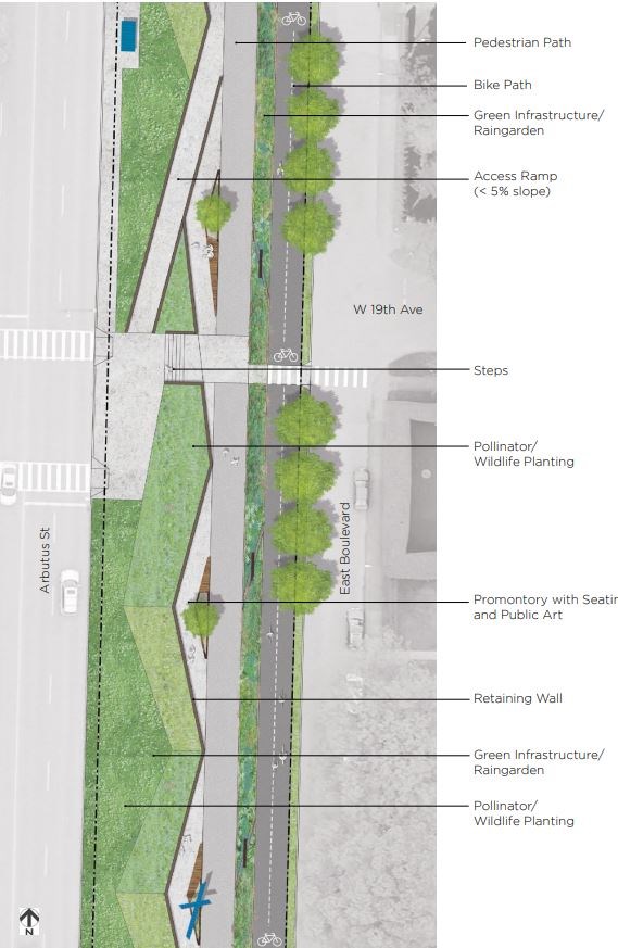
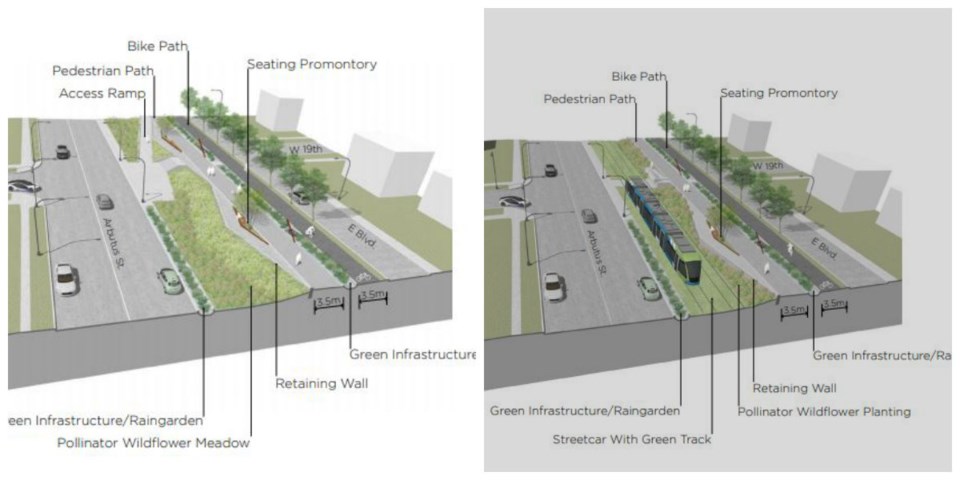
Transportation design for this zone includes 3.5-metre pedestrian and cycling paths, as well as physical separation between pedestrians and cyclists.
The plan for the “The Lookout,” or zone eight, is to create an accessible viewing platform that overlooks the Fraser River, the airport and Georgia Strait. The design would also include wildlife habitat, rain gardens, lighting, benches and other amenities.
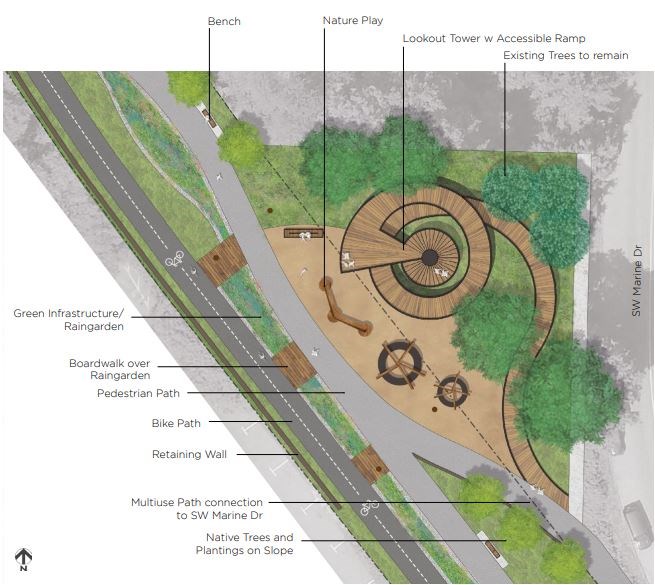
Transportation design for this zone includes 3.5-metre pedestrian and cycling paths, as well as a physical separation between pedestrians and cyclists.
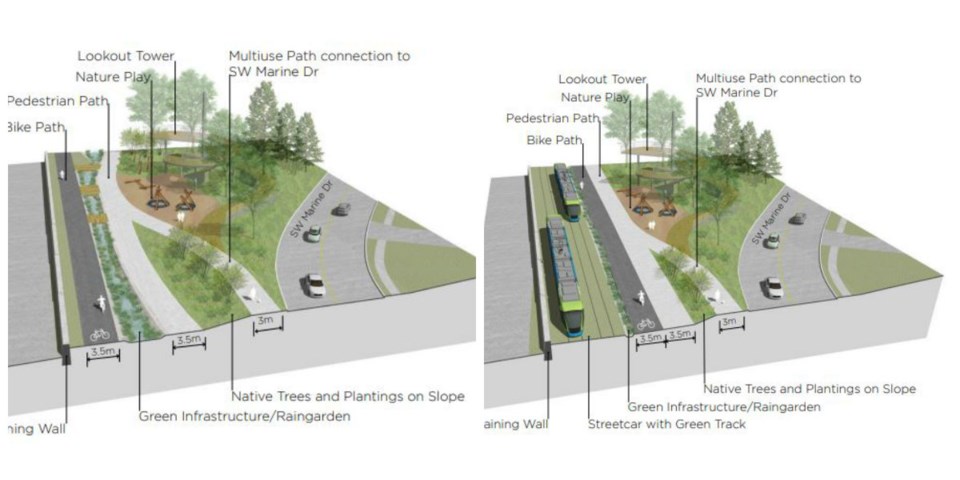
(Long-term transportation plans for both of the zones include 7.6 metres for streetcar tracks, a physical separation between the streetcar and cyclists, the 3.5-metre pedestrian and cycling paths, and a physical separation between cyclists and pedestrians. The walking and cycling infrastructure along the corridor would need to be reconfigured in some areas when the streetcar service is implemented.)
City staff have been collaborating with, and will continue to collaborate with, the Musqueam, Squamish and Tsleil-Waututh First Nations about the overall greenway project on aspects such as naming, ethnobotany, wayfinding, storytelling and public art.
Subsequent phases of the Arbutus greenway construction will be decided based on future councils’ priorities and funding.
An opportunity exists, meanwhile, to partially fund the purchase and future development of the greenway through the development of surplus city-owned land.
Staff have identified two parcels of surplus land outside of the greenway on the adjacent street right-of-way serving East Boulevard in Kerrisdale (zone 5).
One is between 37th and 39th on East Boulevard, the other is between 39th and 40th.
The city could release the lands for other purposes such as development and use the revenue from them to fund the purchase and overall implementation of the greenway, the report states. But the potential rezoning of the land would be considered in a future planning process that includes public consultation.