
The most important advice you need for any hike at Buntzen Lake is this: Get there early!
Before 10 a.m. is preferred, earlier is better. Later than noon? Don’t bother.
Buntzen Lake is one of the most popular multi-use recreation areas in the Lower Mainland, so parking fills up fast. I repeat: Get there early.
Another piece of advice: use GPS or online maps to find your way there. Even with existing direction signs, it can still be confusing since one route winds through new sub-divisions in Coquitlam.
But once you reach Buntzen Lake (early!) you have numerous options for great hikes, each with various degrees of difficulty.
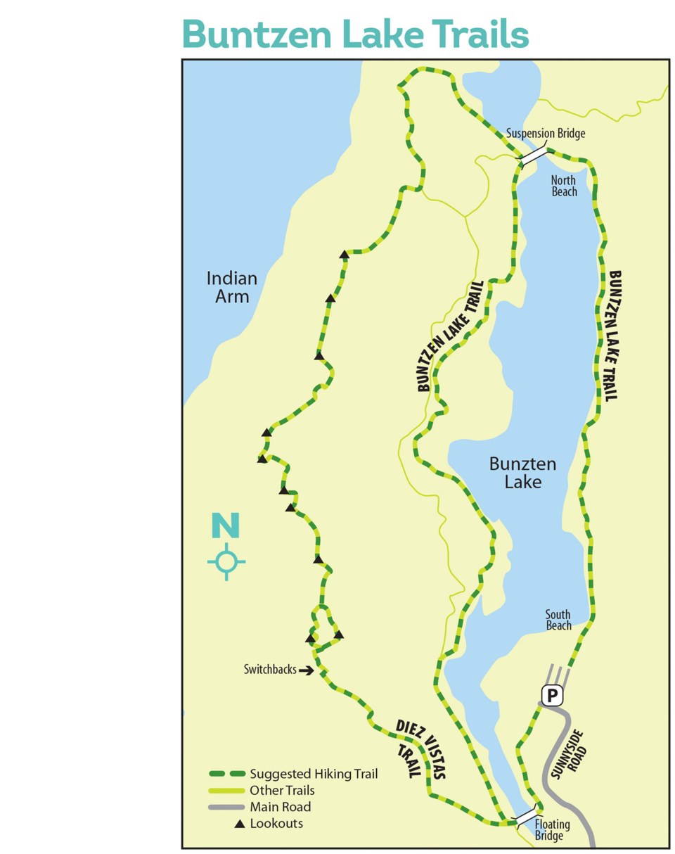
The easiest, most family-friendly hike is the three-kilometre Buntzen Lake Trail that hugs the east side of the water to reach North Beach at the northern end of the lake. There is minimal overall elevation gain, but the well-marked and well-maintained trail rises and falls (never too steeply) and passes a few off-shoot trails to small lakeside spots.
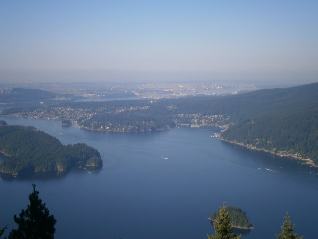
The beach is a great place to enjoy lunch and take in the peaceful view. Just east of the beach is a huge outflow water pipe, the end point of a tunnel that begins four km to the east at Coquitlam Lake and runs under Eagle Mountain.
The Buntzen Lake Reservoir and recreational area is BC Hydro property. The water is used to generate electricity at a power station north of and far downhill from the reservoir, along Indian Arm.
From North Beach, you can simply re-trace your steps along the easy route. Or for a longer, more strenuous return, cross the suspension bridge and hike the west side of the Buntzen Lake Trail. Five-kilometres long, this side also has steeper sections that rise in and out of the rainforest. Bring plenty of water.
After the trail joins a gravel road for the last kilometer, return to your car by turning left at the “Floating Bridge” crossing the narrower south end of the lake.
For well-prepared and fit hikers looking for more of a workout and even more spectacular views, the Diez Vistas Trail (it translates to “ten views” in Spanish) is a popular choice. But be prepared for a climb over 500 metres elevation gain and bring extra water. You might want to re-name this hike the “Diez Heart Attacks” trail by the time you’re done — but it will be worth it.
The trailhead is at the southwest corner of the parking lot. Follow the flat trail south, turn right to cross the Floating Bridge, then stay straight as the first section rises immediately through second-growth forest. Large cedar stumps and remnants of an 100-year old “skid road” characterize the logging history of the area.
After a clearing under power lines, the real effort begins. The rocky, rooty trail moves northwest around and over a ridge to the west-facing side of the mountain, then begins a series of switchbacks that will test your fitness (I suggested calling this section the “Diez Switchbacks”).
After the first series of switchbacks you emerge — likely sweating — at a small rocky outcrop looking southwest to Belcarra Park. Many first-timers assume this must be Vista No. 1, but alas, it is not. It’s a great place for a water break, but more climbing and switchbacks are ahead before you finally reach the official first Vista.
And what a vista! On a clear day, the deep blue waters of Indian Arm shimmer like a jewel and Deep Cove is framed perfectly to the west. Behind it you can see downtown Vancouver and even glimpse Vancouver Island. Mount Seymour’s first peak and ski resort buildings are also easy to pick out.
If Vista No. 1 is enough — and for many people it is — return downhill through the switchbacks or via a side trail loop that leads to an east-facing lookout over Buntzen Lake.
Or you can continue north along the plateau trail to the rest of the Diez Vistas. Keep in mind, however, time and inevitable tree growth has obscured many of the vistas. Close to half are now blocked by trees, but the ones that still offer views are worth the time and trouble.
The trail eventually drops down to intersect with the steep, downhill Lakeview Trail and the Old Buntzen Lake Trail, for your return trip.
Mike Hanafin is an avid backcountry hiker who can see the forest and the trees.


