
A wise person recently told me, “More people need a reason to go to Bowen Island.”
Let’s add great hiking to that list of reasons. For the cost of a 20 minute ferry ride to Snug Cove, you can hike to a mountain top or walk around a serene lake — or both.
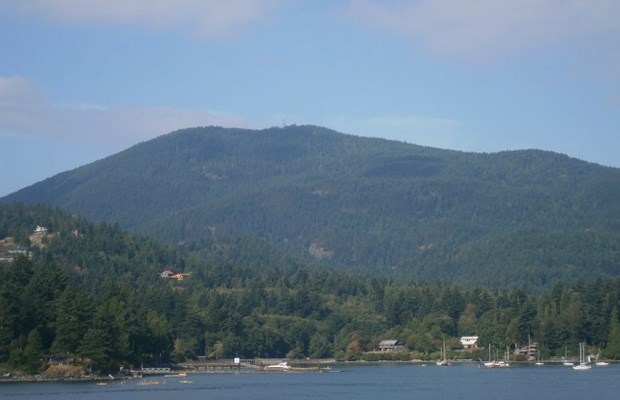
Originally this column was intended to describe the hike to the top of Mt. Gardner, Bowen Island’s highest peak at 720 metres, but because that hike is a bit of a brute and not for everyone, we’ve also included a visit to picturesque Crippen Regional Park, which is much more family friendly and requires much less effort.
Two pieces of advice: (1) leave the car at home and bring a bike if you can, and (2) bring plenty of water because you’ll need it. (Bring two litres minimum for the mountain hike.) The bike speeds up the journey to and from the Mt. Gardner trailhead, which is three kilometres from Snug Cove.
Also make sure you grab the Bowen Island tourist map onboard the Queen of Capilano, or at the visitor information booth after you get off the ferry. It is a great supplement to the hiking map we’ve provided.
You don’t need a car to reach Horseshoe Bay Terminal; the 257 Express bus has frequent service from downtown Vancouver (starting at Dunsmuir and Cambie, with pick-ups along Georgia). Check the TransLink and BC Ferries websites for exact departure times.
After enjoying the fresh air of Howe Sound, leave the Bowen ferry terminal and turn right at a well-marked trailhead for the Alder Grove Trail into Crippen Park. After passing (or exploring) the fish ladder on your right, turn right and follow Miller Road for about 100 metres until you see the Killarney Creek Trail across the road.
Head west along the wide, smooth trail, enjoying the shade and listening to birds in the trees. A number of large trees managed to survive logging, but one huge tree has fallen right beside the trail in the last two years, leaving a splintered stump and an opening in the forest canopy. Can you see the early signs of re-growth thanks to sunshine reaching the forest floor?
As you approach Killarney Lake, turn left towards a picnic area and park bench at the dam. Then turn right onto a loop trail that hugs the lake’s edge and gives you multiple vantage points for photos. Bird spotters can often be seen with binoculars.
You can continue hiking or biking around the loop, or — if Mt. Gardner is your primary goal — turn left at a well-marked junction and head uphill to Mt. Gardner Road. Turn right and follow the road until you reach post 490, at the intersection with “Hikers Road”. Cross the road carefully and get ready to start sweating!
There are many routes up the mountain — some marked better than others, and some parts not properly signed at all. Old and surprisingly inaccurate maps from hiking books add to the confusion for many hikers. Hopefully our map corrects that.

If you want the least confusing but consistently steepest way up, take the Skid Trail to the Mt. Gardner South Trail and turn left. For a longer and slightly gentler trip (but still plenty steep in places), turn right after the Skid Trail and follow signs and red tree markers to the Handloggers Trail and the Mt. Gardner North Trail. The biggest advantage of this route is that it takes you to a rocky bluff with spectacular views of the Sunshine Coast.
On a recent excursion I came across two groups of hikers struggling to follow incorrect maps and confusing signage. The good news is, all the routes eventually reach the destination. But my suggested route tries to avoid most of the rough logging and service roads.
After turning right after the Skid Trail, you follow a short smooth path heading north to a junction with the Bowen Pit Road, which comes up the hill towards you. You’ll be making a U-turn to the left here, but on the right is a small viewpoint, good for a quick stop.
Follow the rocky road uphill as it curves to the right… until you see a small path marked by flagging tape and red tree markers on the right. Turn here, and head north again, as you join the Handloggers Trail. The trail gets off to an inauspicious start, as you are forced to scramble down and back up a dry creek bed (where a small bridge may have collapsed).
Stay on the relatively flat Handloggers Trail as it curves west through second growth fir trees. There are some junctions with old roads and sketchy trails, but don’t turn off until you reach an obvious junction with a small sign that points left to Mt. Gardner.
From this point, the climb begins in earnest. Follow the red tree markers wherever possible. There is one tricky section where the path joins a gravel road with power lines overhead, then does a sharp U-turn to the right. Eventually you’re back on a proper uphill trail until you reach the Sunshine Coast Viewpoint, looking across to Keats Island and Gibsons.
Re-hydrate before leaving the bluff for the final uphill climb to the peak. A fork in the trail gives you options for the last stage. The left fork is the most direct route to the North Peak but it is much steeper, including one section with ropes and chains to help you ascend. In the spring this route can also be icy, so be careful. If ropes and chains aren’t your thing, the right fork eventually loops back to the peak via a much less severe climb.
A wooden platform (actually helicopter pad) among a myriad of communications towers at the North Peak is ideal for lunch and enjoying the unique views looking east to Vancouver, Horseshoe Bay and the mountains rising from Howe Sound.
For the trip down, leave the North Peak area via a small opening at the south end of the platform. The trail passes a cut-off to the slightly higher South Peak, but don’t waste your time and energy — there’s not much view from that peak. Turn left at the junction with the Mt. Gardner Trail. The well-marked South Trail is recommended for the descent and it leads to a shortcut back to the Skid Trail and eventually the original logging road connecting to Mt. Gardner Road. The bike really comes in handy here, for a fun, mostly downhill ride back to the village and ferry terminal.
Mike Hanafin is an avid backcountry hiker who can see the forest and the trees. Tell him about your favourite hikes at mhanafin@shaw.ca.


