
Note: This story has been updated since first published.
***
Not every great hike on the North Shore involves reaching a mountain peak, or even working up a huge sweat.
Sometimes it’s great to just go for a family (and dog-friendly) walk in the woods.
The Fisherman’s Trail offers a serene rainforest hike, along with history lessons, a perfect view of a 2014 rock-slide — AND a chance to cross a new suspension bridge.
The Fisherman’s Trail starts at the south end of the massive Lower Seymour Conservation Reserve (LSCR) which was opened to the public in 1987. Our suggested hike only covers a fraction of the total trail (which extends approximately 15 kilometres north to the Seymour Dam and reservoir), but it’s a great introduction to an area full of history and great scenery.
The most direct trailhead is at the north end of Riverside Drive (accessed from Mount Seymour Parkway). However, non-residents are not permitted to park near the Riverside Drive trailhead from May to September, so during the summer it’s best to park at another access point off Hyannis Drive (accessed via Berkley Avenue — see map).
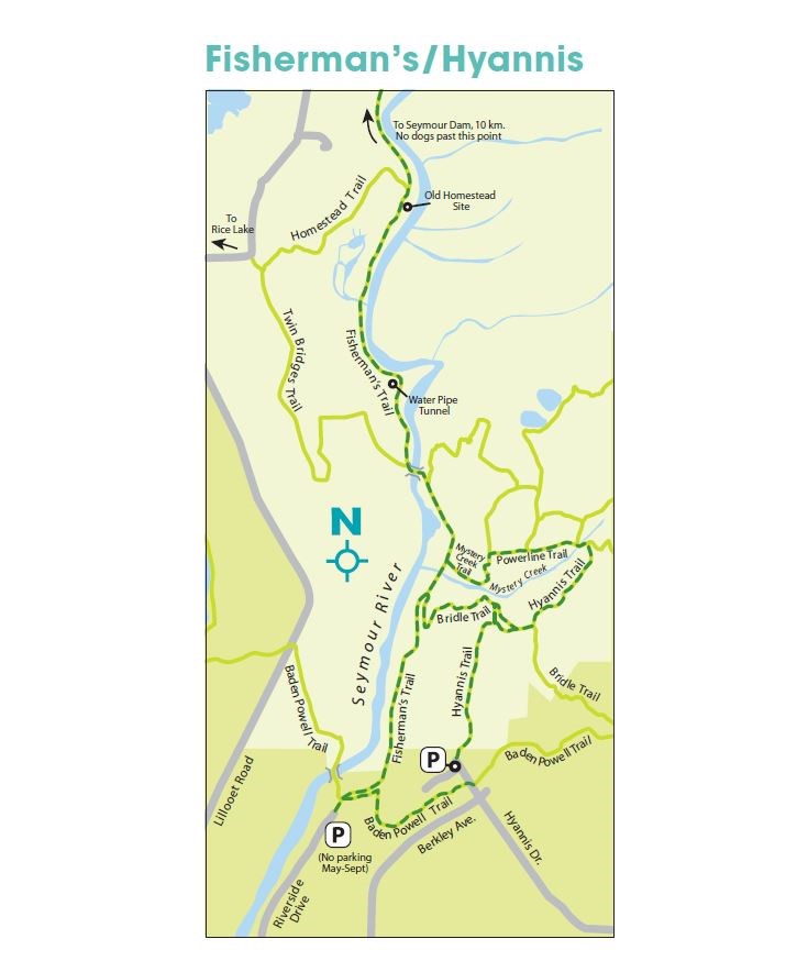
The Hyannis Drive spot is a popular hub for numerous well-marked trails heading west, north and east. The west option uses the Baden Powell Trail to connect directly to Fisherman’s, and north gives you various options to reach the same trail via Bridle Trail or Mystery Creek. Pick whichever one you like, and use a different route on the way back.
Fisherman’s Trail is actually the remnants of an old logging road running parallel to the Seymour River. Commercial logging in the LSCR finally ended in 1994. The Seymour River valley has also been a source of water for the Vancouver area since 1908, and parts of the watershed (north of our suggested hike) are strictly off-limits to dogs.
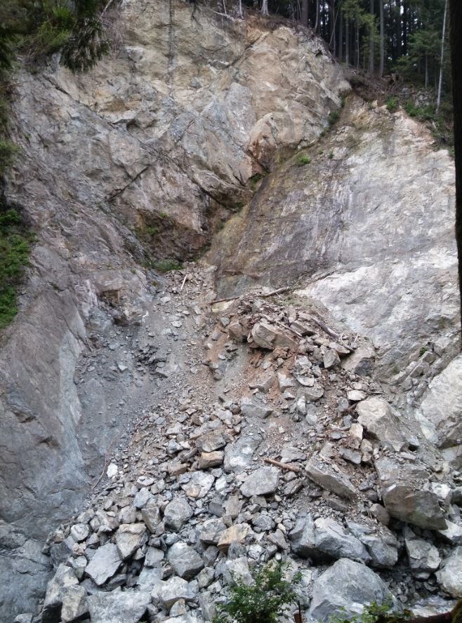
The trail is wide and gentle, and the first kilometre has occasional views down into the river-canyon on the left, with moss and fern-covered rock-faces to the right. After 15 minutes you’ll notice extra safety-fencing along the canyon edge, as you approach the rock-slide viewpoint near the junction with Bridle Trail.
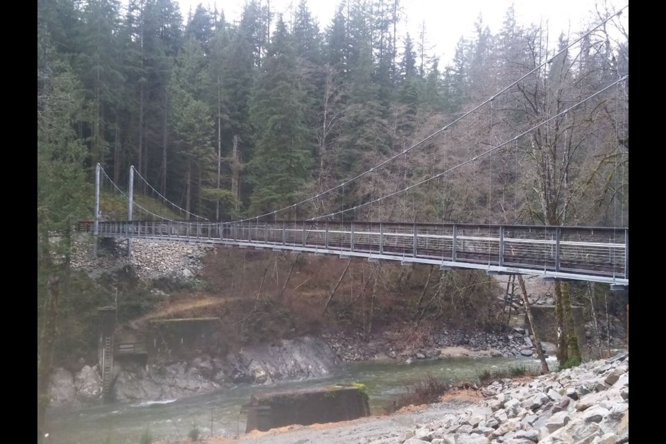
In the early morning hours of Dec. 7, 2014, a massive chunk of the west bank of the Seymour River Canyon broke away, sending boulders and trees crashing over 80 metres down to the river below. An estimated 50,000 square metres of rock was dislodged, damming the river and creating dangerous flooding upstream. Almost immediately, the river overflowed a concrete bridge, which had to be removed permanently. Four years later, the Seymour Suspension Bridge was opened to re-connect the Fisherman’s Trail on both sides of the river.
The $2 million bridge — 73 metres long and 2.5 metres wide — was constructed for hikers, cyclists and equestrians. It is over 20 metres above the river (depending on water levels) to avoid any potential flood risk created by the rock-slide. The bridge promises to become an attraction for locals and tourists alike.
The suspension bridge is the fourth structure to cross the Seymour River in this spot. The original bridge (1908-1992) carried a water main and pedestrians. A second steel bridge (hence the references to “Twin Bridges”) was built in 1926 for the logging road, and lasted until 2009, when it was replaced by the concrete bridge with blue railings. A small piece of rusted steel girder from one of the “twins” is on display on the west side of the river.
After crossing the river, Twin Bridges Trail goes uphill to the left toward Rice Lake, while the Fisherman’s Trail continues north to another history lesson — the entrance of a short tunnel which was blasted out of a rock wall for an old water pipeline. If you have a flashlight, you can try walking/crawling carefully through the tunnel, but most people (including me) are satisfied to just look inside.
Less than a kilometre north of the tunnel is a pair of moss-covered wooden supports, which mark the entrances to former homesteads dating back to the early 1900s. Some artifacts, plus remains of foundations and a chimney are still barely visible in the bush.
Just ahead is the junction with the Homestead Trail, which rises steeply to the left towards Rice Lake. A gate also marks the upper limit for dogs on the Fisherman’s Trail. The trail continues beyond, but if it’s time to turn back, simply re-trace your steps to cross the bridge, and choose a route back to the trailhead.
Mike Hanafin is an avid backcountry hiker who can see the forest and the trees. Reach him at mhanafin@shaw.ca.


