I’m a crime buff.
So is my mom. We watch a lot of crime shows, especially British ones like Vera or Silent Witness. I haven’t been able to entice her into Mindhunter, but I digress.
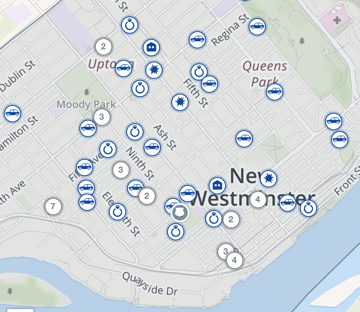
So when I found out that the New Westminster Police Department uses CrimeReports.com for online crime mapping, I got pretty excited.
And then I got lost down the rabbit hole.
I went on it and spent hours studying what crimes were happening in what areas of New West.
If you haven’t checked it out, it’s worth it. Just go here.
What you’ll find is a detailed map of New West, listing all of its neighbourhoods. On the map are little icons like a diamond ring or a car or a house. Click on an icon and you’ll get what the specific crime was (like theft under $5,000 or breaking-and-entering) followed by the day and estimated time. Sometimes there will be a circle icon with a number in it – when you click on that it shows a cluster of crimes in one location. For example, on Friday I clicked on a number 7 and there were that many breaking-and-enterings around the 1300 block of Caribou Street. Somebody obviously went on a crime spree.
The goal, according to the police website, is “to provide the public with crime statistics on a Google-based map along with a descriptive summary.”
It should be noted that, according to the police, “the data shown on CrimeReports.com does not include all offence types and does not accurately reflect the total number of incidents for the area. The data may sometimes indicate where an incident was reported rather than where the incident occurred. To protect certain types of police information, and to ensure that victim, witness, or suspect information is not compromised, information is generalized to a 100-block level, as opposed to a specific address. For example, 500 Block Columbia Street is used instead of 555 Columbia Street. The data does not reflect statistics reported to the Canadian Centre for Justice Statistics.”
But the data does give a general idea of where the most crimes happen in New West as well as what types during a given period of time.
I’m not sure what to make out of looking at the crimes of New West. They are pretty spread out, although some areas, like downtown, of course, see more than west Queensborough.
In an age in which man police departments have become overly-secretive, this kind of data is a little refreshing.
Follow Record Editor Chris Campbell at shinebox44 on Twitter and Instagram.


