
Wow! What a week that was! Have you broken out the sunscreen yet? Well, you can probably put it away this weekend after the city experienced above average, summer-like high temperatures during the workweek. In fact, when you put the sunscreen away, you may as well pull out the umbrella at the same time because those clouds coming in from across the Strait of Georgia don’t have good intentions, other than to water your garden, of course.
Our fascination with weather peaks our curiosities and has fueled much water cooler chatter. Weather pulls at our heartstrings, inspiring us one day and disheartening us the next. As Environment Canada’s senior climatologist David Phillips notes, we are a fickle bunch.
“We like to have weather in a Goldilocks kind of way - not too much and not too little,” said Phillips.
The past few weeks have shown a frustrating preponderance of clouding over, right in time for the weekend but all that should eventually change as summer rolls in. And roll in it will, according to the forecasting company Accuweather, which has predicted a favourable summer for the Coast:
“Western Canada will have a warmer, drier summer compared to normal. In Vancouver, the combination of high pressure and above-normal sea surface temperatures in the northeast Pacific will lead to a slightly warmer summer than normal with reduced chances for rainfall.”
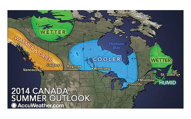
Environment Canada’s own forecast suggests the same.
“We’re calling it to be significantly warmer. There’s no doubt in our minds,” Phillips said.
“Who would complain about that weather? Although my sense is that it may pose problems for firefighters and domestic water levels,” added Phillips.
That doesn’t sound too bad. But how are climatologists so sure of this forecast? And why do we see such noticeable fluctuations in weather, sometimes on an hourly basis and from neighbourhood to neighbourhood?
These types of questions have been studied for centuries and, as it turns, out modern-day climatologists are able to examine very small fluctuations in weather, even from street to street. But are their predictions something to bet the house on? Well, probably not, but it’s getting there, according to Roland Stull, a professor of numerical weather prediction at the University of B.C's Earth Ocean and Atmospheric Science department.
“We can forecast over someone’s house. Air is fluid, obeying the laws of fluid dynamics. It’s not perfect, but we can use equations that can forecast for thousands of points around the Lower Mainland. The main reason we don’t see it, is it’s hard to communicate the information to the public,” he said, noting media need to amalgamate information for large population centres.
Stull said he uses his own hyper-local forecasts to navigate his pleasure aircraft. “I rely on these forecasts rather heavily,” he said.
“The latest development in forecasts is making probabilistic forecasts - telling you what they think the weather will be and also what the mistakes in forecasting will be. Again, the problem is communicating this,” he said.
Stull likens forecasting to a rubber balloon.
“The nature of weather is very chaotic. Take a toy balloon. Instead of tying it off, let it go. The balloon is a simple system, but yet you can’t predict where it will fly. That’s an example of a chaotic system in nature; it’s a simple system, but it’s hard to forecast. Well, the atmosphere is also a chaotic system but even harder to predict,” he explained.
So what of Richmond? As it turns out Metro Vancouver has a very dynamic microclimate that Richmond is affected by and contributes to.
UBC associate professor of climatology Andreas Christen has spent years studying the impact of urbanism on local climates.
According to Christen, there are a number of geographical as well as man-made factors that can affect the weather in Richmond.
Take fog, for instance.
“In Richmond the complexity is that it is a coastal city and there’s often fog on the ocean. You can’t dispel the strong impact the ocean has to create fog,” said Christen.
However, “in short, there is less fog in the city centre of Richmond as opposed to rural farm areas. Where previously there was fog, and buildings have since been built, there will be less fog,” said Christen, of a phenomenon most Richmondites will have observed if they drive across the city on a foggy day.
This is because fog requires colder temperatures to cool down water vapour into suspended droplets of water. As a result of development over the course of the past four decades the city centre has formed what is known as an urban heat island effect, thus we get foggy Steveston and sunny Richmond Centre mall.
An urban heat island is a metropolitan area that is significantly warmer than its surrounding rural areas due to human activities. Two principle factors contribute to heat islands: Firstly, materials like metal, concrete, asphalt and glass absorb heat whereas trees and vegetation cool the ground. Secondly, buildings, cars, air conditioners, machinery and humans themselves produce heat. Other factors include pollution and geometric effects like sunlight reflecting off multiple surfaces. Richmond’s heat island epicentre is arguably the corner of Westminster Highway and No. 3 Road. The only saving grace for these heat islands is that buildings can cast shadows, giving people some relief from the sun.
Notably, heat islands can affect energy consumption as well. Studies suggest there can be a 10 per cent savings in heating bills if one lives in a heat island. Conversely, this may entice people to buy more air conditioners, adding to the effect.
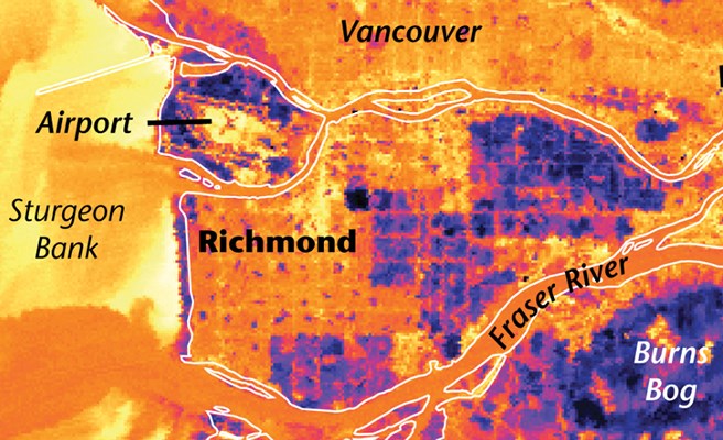
Christen has studied satellite imagery that measures surface temperatures in Richmond. Notable, are the hot red spots of malls, the city centre and industrial areas juxtaposed against cool blue spots where farms and parks rest.
One study had a vehicle drive around Metro Vancouver recording air temperatures (red being hot, orange, warm and blue, cool). The vehicle left a red trail through Downtown Vancouver and Richmond’s city centre until it turned blue when it reached farm fields south of Steveston Highway. Temperatures varied by about four degrees.
“Urban planners think about how we can mitigate these high temperatures” to prevent heat-related stresses on people, particularly seniors, said Christen.
So, it is fortunate that the new Kiwanis Towers seniors’ complex is next to Minoru Park.
“What I find intriguing is that parks appear as little cold dots on the temperature map, meaning they’re essentially islands where it’s a little cooler,” said Christen, noting the significant dark blue square that is
the Garden City Lands bog.
Christen notes, however, that these pockets of cool land only propagate one or two blocks into the city.
Heat disparity in Richmond is also a result of a neighbourhood’s proximity to the ocean, which creates a “conservative atmosphere,” meaning there is less variation, as water takes longer to cool and warm than land. As Christen notes, in the summer, temperatures are warmer in East Richmond as the sun heats the land while the ocean acts as a coolant for West Richmond. The reverse is true in the winter, thus it’s more likely East Richmond will see more snow, especially in places where there is no heat island. The ocean factor is much more pronounced when you compare the variations in temperature and snowfall between Richmond and Abbotsford.
The ocean also contributes to windier conditions in West Richmond, especially Steveston, where winds tend to approach from the west, with the strongest winds coming from the southwest as they accelerate across the length of the smooth Salish Sea. As wind moves over land it is faced with friction in the form of trees and buildings, explained Christen.
He notes Richmond’s apartments — although they are not too tall — in the city centre can form wind tunnels and gusts.
“Wind is stronger in higher parts. Wind goes around and also pushes down (apartment buildings) and it is this high wind, which is normally in check, that can create gusts at the street level. In poorly designed areas it can knock down people. Of course, to the credit of engineers, this is avoided by proper models,” explained Christen.
A place where one may experience these urban, man-made gusts is along Firbridge Way in the City Centre area, especially as new towers are going up.
Christen notes there are advantages to these gusts. For instance, wind can flush out air pollutants and can also cool the heat island.
“I don’t dare say apartment buildings are good or bad for weather,” chuckled Christen.
Winds are also an important contributor to the most obvious factors in the weather forecasts affecting Richmond – clouds, precipitation and sunshine.
Circulating winds are one way the atmosphere forms those puffy clouds, most common in the spring, fall and winter, and which often contain rain showers, said Stull.
“We’ll get cases where the winds above the ocean surface are bringing colder air in the mid-atmosphere over warmer air toward the ground. …The warmer air wants to rise and the colder air wants to sink, creating turbulence resulting in cumulous clouds,” explained Stull.
These cloud formations are what cause those spotty showers, said Phillips.
“In summer, rain is more spotty, it rains in your front yard but not in your back yard,” he said.
Also, and importantly, winds brushing up against the North Shore Mountains cause different factors there than in Richmond.
Orographic lift is the process whereby winds hitting against a slope are forced upward to create clouds, and in most instances, precipitation.
This process can be compounded when existing weather fronts crash into the North Shore Mountains, as it can produce even more precipitation than the original front contained.
“Clouds move with wind and bump into mountains and then the only ability for the wind to move is to go upwards and, while it moves upwards, the atmosphere cools, causing water vapour to condense, thus creating rain,” explained Christen.
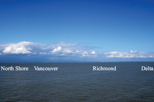
Such an effect results in the infamously soggy North Shore and this dissipates southward across the Lower Mainland.
“The closer you are the more uplift you have,” said Christen. This effect can be seen if you take a boat into the Strait of Georgia, say on a BC Ferries vessel, on a variably cloudy day - clouds bundle up against the mountains and slowly decline the more south one looks.
Consider that the next time you’re enjoying a smug, sunny afternoon at Garry Point Park while the North Shore is shrouded in thick clouds (although West and North Vancouverites will have their day of judgement come those foggy, winter days).
As for Richmond itself, it’s naturally cloudier in north Richmond as opposed to south Richmond, which sees about five per cent more sunshine, according to Christen. Depending on the time period chosen, Christen said the most northern parts of Richmond, such as the Bridgeport area, will see about 1300 millimetres of precipitation whereas the south will see about 900 millimetres - Stevestonites and Shellmontians rejoice!
Of course, this information isn’t meant for Richmondites to draw lines in the sand. No, there is no need for Terra Novans to brag about the cool ocean breezes on an overly hot summer day or Stevestonites to feel less about themselves for being shrouded in fog for weeks on end.
Although, as Phillips notes, we all like to have fun with each other.
“Now, don’t forget the June Gloom,” he said from his office in Toronto.
Oh yes, that.
“We cheer when you guys get it because you’re always sending us flower counts in the winter. We’re drinking beer on patios and sometimes you get that coastal situation that sticks, denying you of a summer situation – the June Gloom!” exclaimed Phillips.
Leaving us with one more tidbit of information, Phillips said the West Coast can expect an El Nino winter.
“The models are suggesting almost a done deal - 70 per cent sure and in my business that’s a good bet,” said Phillips.


