After eight days of meetings and deliberations, the False Creek Flats arterial community panel has settled on a route for the new arterial connection.
The City of Vancouver announced April 6 that the top-ranked route by the panel was the National-Charles option.
“This is the route that we proposed in our A Better Way report and so we are thrilled,” Dan Jackson, chair of the Strathcona Residents’ Association said in an email.
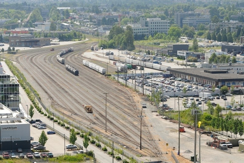
The National-Charles route would see the arterial connect Main Street and Clark Drive with an S-curve around Trillium Park and the National Works Yard. It would include an overpass that would start east of Chess Street, pass through and over the fire training facility, the rail yard, Vernon Drive and align with Charles Street.
It was included as an option proposed in the Strathcona Residents’ Association report and was not one of the options initially proposed by the city.
The aim of a new east-west arterial route and overpass will separate the rail corridor from the roadway and reduce the impact of train traffic on the area, enhance safety and alleviate congestion. City staff has been working to identify a route since the fall of 2015.
Council approved the False Creek Flats area plan last spring. The plan includes the transition of Prior/Venables to a local serving street once the new arterial is complete. The arterial overpass was initially included as part of the area plan but was separated from that process to allow for more community input.
The community panel was convened in October and met over a total of eight days to learn about and discuss each of the nine options. Using a ranked choice voting method, the panel members ranked five of the route options — Prior/Venables-Underpass, Malkin North, National-Grant, National-Charles and National-Civic Facilities. In the end, the National-Charles route came out as the top-ranked option with 67.6 per cent of the votes. Prior/Venables-Underpass was the runner up with 32.4 per cent.
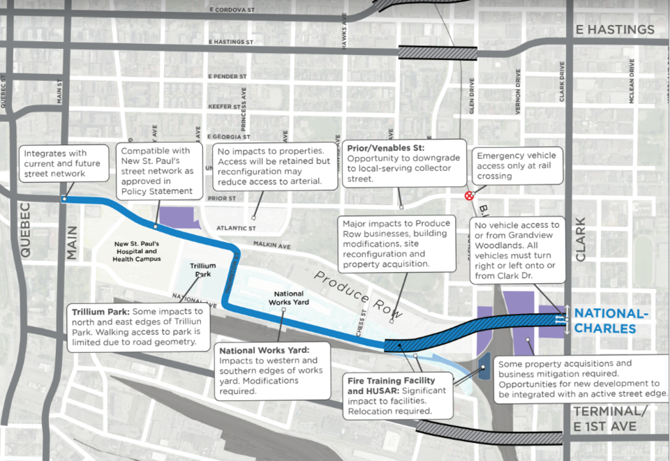
The panel noted a number of reasons why National-Charles is the preferred alignment, including allowing for the downgrading of Prior to a local street, leaving Strathcona Park unaffected and keeping the arterial further away from homes, improving air quality for residents.
It also has less impact on the businesses along Produce Row on Malkin Avenue.
“We’re very happy,” said Damien Bryan, general manager of Discovery Organics, of the several produce businesses along Malkin. “Produce Row is very happy with the decision to protect the Malkin Avenue corridor and the jobs in the food hub… It’s a great step forward. It solidifies a lot of the arguments we’ve been putting forward in the aspect of protecting Produce Row, protecting Malkin Avenue from being a corridor and thus protecting a bunch of businesses, a lot of jobs, it also protects Cottonwood Gardens, leaves the park alone.”
He said if Malkin is chosen as the route for the arterial, it would be mean several of the Produce Row businesses would have to relocate or go out of business.
Theodora Lamb, executive director of Strathcona BIA, said all of the options have drawbacks, and in the case of National-Charles, it is the cost.
It is the most costly route due to the fact that it has the widest span over rail and would require more land acquisition and more construction costs. Preliminary estimates are in the range of $345 to $485 million. The estimated costs of the other routes run from a low of $65 million to a high of $265 million.
“We’re happy to see that the community consultation approach landed on a really strong majority outcome, regardless of the decision we still need to ensure that the grade crossing at Venables and Clark, which was part of the other proposed arteries, is addressed,” Lamb said.
Rail traffic has increased in the last 18 months, she said, and delays can last up to 20 minutes eight times a day.
Lamb said that each of the routes comes with a set of pros and cons, and the association’s focus is ensuring that no matter which route is chosen in the end, the decision is made in consultation with local businesses.
“We really want to ensure that there is no industrial land loss in the development of the overpass in the Nat-Charles option,” she said. “We can’t afford to lose anymore industrial land… whatever is built and whatever ends up coming through there it has to be in concert with the industrial businesses already operating there.”
This is not the end of the process, while the community panel voted to recommend the National-Charles route, it’s not a binding decision. The final decision on the future arterial route rests with city council and the park board.
The panel will present its findings to city council on April 24 and to the park board on April 30.
City staff will then be tasked with taking the public input in the panel’s report and undertake more technical and feasibility analysis, before coming back in the fall with a recommendation.
Check out all the route options here.
@JessicaEKerr
jkerr@vancourier.com