A project using ocean currents is meant to show which Vancouver beaches would be affected by an oil spill from increased tanker traffic if the Kinder Morgan Trans Mountain pipeline expansion goes ahead.
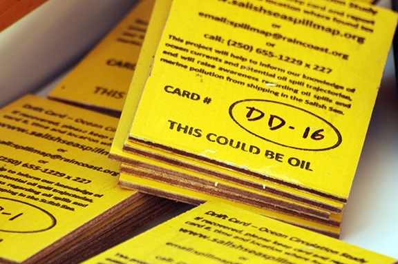
In late October, the Georgia Strait Alliance dropped 1,600 yellow four-by-six inch plywood cards engraved with information about the project and reporting directions along the current tanker route. The project was based on the idea that the cards would drift along the same currents that would carry an oil spill.
Data from the 400 cards reported so far suggests False Creek Yacht Club and English Bay beach would be two of the popular Vancouver spots oil would reach. Other cards were found along other coastal areas including Jericho Beach and as far as Tofino on the west coast of Vancouver Island.
Alexandra Woodsworth, energy and shipping campaigner with the Alliance, said the cards are a good way to predict how oil would travel.
“There are obvious differences between a plywood card and oil and we are very aware of that, but these kinds of drift cards have actually been used by a number of government agencies both in Canada and in the U.S. to mimic ocean circulation patterns,” she said. “So they are a tried and true way of telling us part of the story of what could happen.”
The project, funded by U.S based Raincoast Conservation Foundation and California outdoor clothing retailer Patagonia, is the first in a series of maps aimed to publicize what campaigners believe is the risk from increased tanker traffic.
Kinder Morgan is set to file a formal application with Canada's National Energy Board on Dec. 16 to twin its 1,150-kilometre pipeline from Edmonton to Burnaby. The move would increase capacity of the system from 300,000 barrels to 890,000 barrels per day, and increase tanker traffic off the B.C. from the five ships per month to approximately one a day, according to the project’s website.
Green Coun. Adriane Carr said the map is an eye-opener for people who may not be aware of the interconnectedness of the ocean.
“It absolutely verifies that a spill in the Burrard Inlet will completely foul our entire beach coastline around Vancouver with that thick tarry bitumen and simply ruin those beaches,” she said.
John O'Connor, the president of the Canadian Maritime Law Association, said if cleanup of a spill were to cost more than all available funding, ship owners would be liable for $100 million and international funds up to more than one billion, with taxpayers on the hook for the rest.
“The Canadian governments — municipal, provincial and federal — would have to decide what to do, leave it to nature or to spend public money for the final stage of cleanup,” O’Connor told the Courier by email.
Carr said a more detailed investigation into the city’s legal obligation in the event of a cleanup is needed.
“But that is so lame, because the point is it has to be avoided and the only away to avoid it is to stop it,” she said.
The Courier contacted Kinder Morgan for an interview, but was sent an email statement from Michael Davies, senior director marine development, Trans Mountain Expansion.
“We understand that probability of a marine incident is an important discussion and we are committed to addressing these concerns in our application to the NEB.”
Kinder Morgan Canada president Ian Anderson told the Burnaby Board of Trade last month the $5.4 billion project would break ground in the fall of 2015 and wrap up in late 2017 if given the go ahead.
(Note: This story has been corrected since it was first posted Dec. 3)