A man breaks into a neighbour’s car.
A family up the street gets its bikes stolen.
Someone is assaulted outside a convenience store around the corner.
As a resident of that neighbourhood, you may not be aware of the mini crime wave that has rolled into your community.
The Vancouver Police Department wants to fill that information gap with the introduction of an online crime mapping tool that gives residents up-to-date data on the types of crimes occurring in their neighbourhoods and across the city.
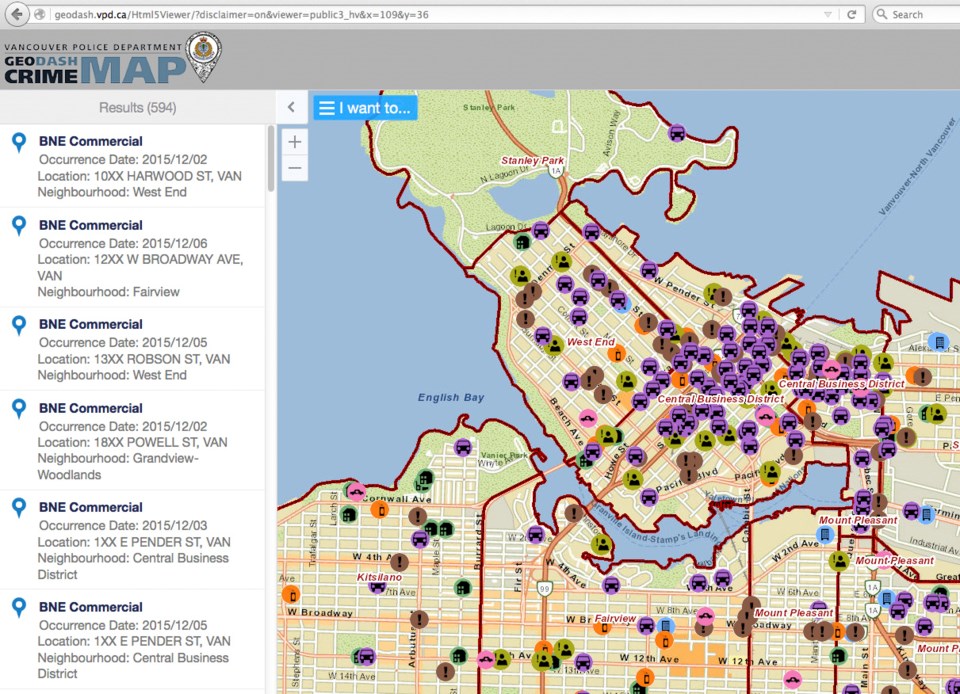
Called Geodash -- geographic data and analysis statistical hub – the system allows the public to use a smartphone, a tablet or desktop computer to zoom in on a neighbourhood on a coloured city map and track crime trends. For example, a user could search thefts from automobiles in the West End for the past two weeks and see on a map where the crimes occurred.
Although the VPD provides crime maps and statistics on its website, the information is dated by a month or two. The Geodash system is refreshed every 24 hours and provides graphs.
“It’s intended to enhance community awareness and provide an open and transparent look at criminal activity in Vancouver,” said Police Chief Adam Palmer in launching the system Tuesday at the Cambie Street police precinct. “We realized that the information we were providing to the public was a little bit behind the times.”
The chief said the system is designed to protect the privacy of victims, noting no personal or identifiable information will be included in the data. Also, he said, any assaults against a person, including robberies or sexual assaults, will only be shown on the map at the nearest intersection. For burglaries and other property offences, specific addresses will not be revealed.
Palmer said he hoped the timely data will inspire residents to join or form Blockwatch groups and participate in other crime prevention programs.
Special constable Ryan Prox, who is the VPD’s analytics coordinator, showed reporters how simple the system was to use and projected a map on a television screen of crime trends in Grandview-Woodland.
“You can see at a very cursory level that there’s some rise in theft from autos around Lakewood [Street], around Third Street and around Parker,” he said, pointing to coloured icons on the screen. “As a citizen of that neighbourhood, that would be something I would want to pay particular attention to, maybe take extra precaution in locking up my items when my car’s parked.”
A more detailed version of Geodash has been used by police officers for more than a year, with Palmer saying “it provides good situational awareness for proactive policing.”
@Howellings