
Only have three hours? Don’t feel like climbing the Grouse Grind but still want to get a moderate workout? This relatively short and quiet, five-kilometre round-trip hike deep through the rainforest passes hundreds of old growth trees on its way to picturesque Whyte Lake. You can also try out the North Shore’s most luxurious outhouse!
To reach the trailhead, take the Upper Levels Highway to Exit 4 (Westport Road). Turn left at the stop sign then follow Westport Road for a little more than one kilometre as it hugs the hillside. Just after the road goes back under Highway 1, turn right into a small gravel parking lot. There is no convenient transit access for this hike.
The trail starts on a gravel road that winds under the highway overpass past an old bridge across Nelson Creek Canyon and then heads uphill. As the road turns left towards a water tank, look on your right for a Trans-Canada Trail (TCT) signpost marking your entrance to the forest trail.
The first section shares the TCT as it heads uphill past huge old growth cedars and fir trees. There are interpretive information boards along the way, explaining ecosystems of the forest and the importance of cedar trees to cultural, economic and medicinal lives of Coast Salish First Nations.

The trail is easy to follow as it steadily climbs uphill, with Nelson Creek in the ravine to your left. Soon you reach a junction. The TCT continues to the right, while you turn left for the Whyte Lake Trail. (Note: Dogs must be on leash from this point on, as the area is deemed ecologically sensitive. Plus, there are numerous steep and unstable slopes off the main trail.)
The Whyte Lake Trail is relatively new and well-marked, running parallel to Nelson Creek for a few minutes, then crossing the creek at a sturdy new bridge before it heads west to follow Whyte Creek. This section is through even deeper rainforest, and you’ll pass more giant trees and some enormous root-balls.
Some sections also have boardwalks to protect the delicate ecosystem. After 15 or 20 minutes you cross a bridge over Whyte Creek, then a slightly steeper incline gets you to a signpost marking a short side trail to the south side of Whyte Lake, which quickly comes into sight.
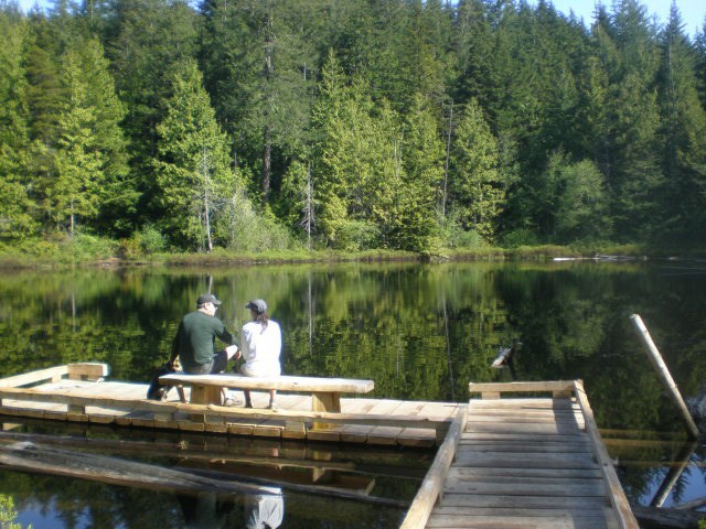
A small boardwalk leads to a floating pier and bench—a perfect place to enjoy lunch in the tranquil surroundings. One tip, especially if it’s a calm day and no one else is at the pier before you: walk gently on the pier to avoid creating ripples on the mirror-like lake surface. Or take some pictures before you walk on the pier; you can get some great photos showing the mirrored image of the trees and sky.
The lake itself is named after Colonel Albert Whyte, a landowner and developer in the Horseshoe Bay area in the early 1900s. Around that time it was also the starting point of a logging flume that carried logs from the lake to near where the ferry terminal is today.
After eating lunch and soaking in the scenery and serenity, nature might be calling. It’s worth a small side trip to Whyte Lake’s cedar outhouse. It’s rare when an outhouse is worthy of mention in a hiking article, but this one is. The wonderful smell of cedar is a natural deodorizer.
Heading back, look up through the trees and you might catch a glimpse of Eagle Ridge Bluffs on the southwest side of Black Mountain. The Whyte Lake Trail connects to the start of the Baden Powell Trail, which climbs up to the bluffs to one of the most spectacular views on the North Shore.
For the return trip from Whyte Lake, retrace your steps mostly downhill back to the TCT, and eventually back to the gravel road and your car.
Mike Hanafin is an avid backcountry hiker who can see the forest and the trees. Reach him at mhanafin@shaw.ca.


